|
How
to Read a Climograph
Every place on Earth has weather. However, different places on Earth
have different types of "typical" weather. Some places are dry,
some are wet, some are hot, some are cold, and some are a little
of everything!
You can find out what
the weather is like where you live by looking out the window or
by stepping outside. Weather refers to temperature, precipitation
(rain and snow), and the wind's direction and speed. Scientists
who study the weather collect information from different places
on Earth and come up with averages, or typical types of weather,
for a particular place. This average, or typical type of weather
that occurs during a year, is called the "climate."
A quick way to get an
idea of the climate of a particular place is to look at a "climate-graph,"
or "climograph." A climograph is what scientists create to show
a particular location's average temperature and precipitation during
the year.
Below is a climograph
for Moose Factory, Canada. To help you learn to read a climograph,
the different parts of the climograph have been identified by number.
A description of each of the numbered parts is given below.
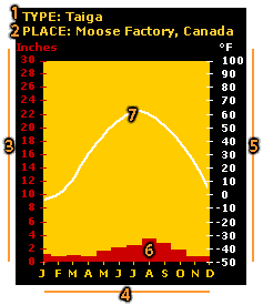 1.
The type of biome associated with the
place. 1.
The type of biome associated with the
place.
2. The place where
the temperature and precipitation were measured.
3. A scale used
to indicate inches of precipitation.
4. The months
of the year. The letters J, F, M, etc., stand for January, February,
March, etc.
5. The temperature
scale in degrees Fahrenheit.
6. A bar graph
showing the average precipitation for each month. In this example,
the average total precipitation is about 1 inch in January and nearly
4 inches in August. (Note: Values for this graph
are found on the left-hand scale.)
7. A line graph
showing monthly temperature during the year. In
this example, the lowest temperature is about -5°F in January
and the highest is about 45°F in July.
(Note: Values for this graph are found on the right-hand scale.)
Back
| Next
|