 |
|
|
|
|
|
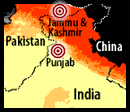
Pick a Region:. . South Asia
Political Physical
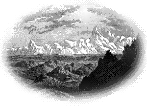
The Himalaya, Karakorum, and Hindu Kush mountain ranges separate the South Asian subcontinent from the rest of Asia. The Himalayas, the highest mountains in the world, extend 1,500 miles west from the Brahmaputra River to the Karakorum, a mountain range that extends 300 miles and lies between the Indus River to its east and the Yarkand River to its west. The Hindu Kush, the world's second highest range, extends 500 miles west and south of the Yarkand River.
To the south of the mountain ranges is the 200 mile-wide Indo-Gangetic plain. The plain is a broad strip of low, relatively flat land lying between the Himalaya Mountains to the north and the Narmada and Mahanadi Rivers to the south. This alluvial plain has been created by the Indus, Ganges, and Brahmaputra Rivers and their many tributaries as they flow from the Himalayas to the sea. The Indus and its tributaries flow south and west to empty into the Arabian sea; the Ganges and Brahmaputra and their tributaries flow south and east to enter the Bay of Bengal. To the south of the plain is the Deccan plateau, a relatively flat highland area that lies between the Western Ghat Mountains ranging from northwest to southeast and the Eastern Ghat Mountains ranging from northeast to southwest. The mountains separate the plateau from the coastline and meet in the south at the tip of the triangular-shaped peninsula known as Peninsular India. Peninsular India juts out into the Indian Ocean. The Narmada and Mahanadi Rivers form the northern border of Peninsular India and separate it from the Indo-Gangetic plain. A narrow coastal plain lies between the Arabian Sea and the Western Ghat mountain range. This plain extends in a southeasterly direction from the Gulf of Khambhai to the southern tip of India. A somewhat wider coastal plain extends in a southwesterly direction from the mouth of the Mahanadi River to the southernmost tip of India. This coastal plain lies between the Bay of Bengal and the Eastern Ghat Mountains. Environmental The climate is influenced by the monsoon, which brings alternating periods of wet and dry weather. Monsoon is a term that means seasonal winds. In the summer time, winds primarily blow in from the sea and bring moisture. This period is called the wet monsoon. During the winter season, winds blow out from the center of the continent toward the sea and convey much less moisture. This period is known as the dry monsoon. The amount of rainfall varies widely from an average of less than 10 inches a year in the northwest to more than 200 inches in the northeast. South Asia contains many different kinds of soil, and the growing seasons for crops vary greatly. Consequently, South Asia has tremendous diversity in plant and animal life. |
|
|
|
|
|
|
|
Privacy Statement and Copyright © 1999-2002 by Wheeling Jesuit University/Center for Educational Technologies®. All rights reserved. |
...