
|
|
Situation It is the summer of 1997, and a new El Niño is beginning. Early indications are that this El Niño will rival the 1982-83 El Niño, the most intense of the century. In Australia, drought advisories have been issued. During the 1982-83 El Niño, rainfall throughout most of the wetter parts of Australia were in the lowest 20th percentile, with many other areas in the lowest 10th percentile. In parts of Peru, 11 feet of rain fell where 6 inches had been the norm. Throughout the world, numerous other anomalous weather events occurred: drought in Brazil, heavy snow in Texas, floods in Europe, and a monsoon failure in India. The biosphere was also affected as crops and fisheries failed. Already, the Southern Oscillation Index (SOI) is showing monthly magnitudes greater than -24. Daily values reached as high as -85 in June 1997. The latest SOI values are here. During the 1982-83 El Niño, monthly values peaked at -35.7. SOI data since 1900 are available. By June 1997, water temperatures in parts of the eastern Pacific were more than 4°C higher than normal, the warmest temperatures recorded in that area since August, 1983.
As the new El Niño develops, an anomaly is also taking place in the winds. For only the second time since November 1982, westerly trade winds replaced easterlies in the Pacific from 160E to 100W longitude.
If the wind has an easterly component, it is shown as a negative on the chart above. A westerly component (anomalous situation) is depicted as a positive value. The value of 850 hPa indicates theses winds were measured at an atmospheric pressure of 850 millibars, about 5000 feet above the sea's surface. Convection had decreased in the western Pacific but increased near the dateline. Faced with a rapidly changing situation, the director of the World Bank and the president of the Northern Insurance Negotiating Organization (Nino) have approached your group of environmental consultants for advice in forecasting the environmental conditions and economic impact that will accompany this developing El Niño. They want to know not only what can be expected from this El Niño with regard to weather, fisheries, and crops, but also how its impact can be softened.
[ Situation ]
[ What Is an Anomaly? ] [ Home ] [ Teacher Pages ] [ Modules & Activities ] |
![]()
HTML code by Chris Kreger
Maintained by ETE Team
Last updated November 10, 2004
Some images © 2004 www.clipart.com
Privacy Statement and Copyright © 1997-2004 by Wheeling Jesuit University/NASA-supported Classroom of the Future. All rights reserved.
Center for Educational Technologies, Circuit Board/Apple graphic logo, and COTF Classroom of the Future logo are registered trademarks of Wheeling Jesuit University.
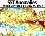 This departure from normal
temperature is called an "anomaly." As you proceed further into your
investigation of the El Niño problem, you will see that much of the data is presented in
terms of anomalies. This presentation tends to be more useful than the actual data, since
the developing conditions are distinguished from the normal. (Information on how anomalies
are computed for sea surface temperatures is included
This departure from normal
temperature is called an "anomaly." As you proceed further into your
investigation of the El Niño problem, you will see that much of the data is presented in
terms of anomalies. This presentation tends to be more useful than the actual data, since
the developing conditions are distinguished from the normal. (Information on how anomalies
are computed for sea surface temperatures is included 