Image of an aerial photograp showing a ridge just outside Mount Rainier National Park.  This image links to an enlargement of area on boundary of the Mount Rainier National Park seen in aerial photograph.
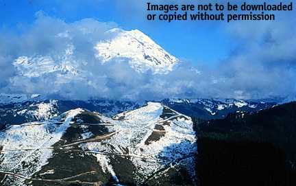
Aerial photograph showing a ridge just outside Mount Rainier National Park. To the right of the clear-cut area on the foreground ridge is old-growth forest within the Glacier View Wilderness area. The Puyallup River flows along the bottom of the valley beyond the ridge. Mount Rainier appears in the background. For a satellite view of this area, click on the image.

Photo: Courtesy of Lighthawk

Button that takes you back to the Temperate Rainforest main page.


HTML code by Chris Kreger
Maintained by ETE Team
Last updated November 10, 2004

Some images © 2004 www.clipart.com

Privacy Statement and Copyright © 1997-2004 by Wheeling Jesuit University/NASA-supported Classroom of the Future. All rights reserved.

Center for Educational Technologies, Circuit Board/Apple graphic logo, and COTF Classroom of the Future logo are registered trademarks of Wheeling Jesuit University.