 |
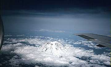
| Aerial photograph of Mount Rainier from
the southwest. Glaciers cover much of the mountain's summit and sides. For a satellite
view of this area, click on the image. Photo: Courtesy of Dr. Stephen M. Pompea, Pompea & Associates. |
|
|
| Aerial photograph of Mount Rainier from
the southwest. Glaciers cover much of the mountain's summit and sides. For a satellite
view of this area, click on the image. Photo: Courtesy of Dr. Stephen M. Pompea, Pompea & Associates. |
![]()
HTML code by Chris Kreger
Maintained by ETE Team
Last updated November 10, 2004
Some images © 2004 www.clipart.com
Privacy Statement and Copyright © 1997-2004 by Wheeling Jesuit University/NASA-supported Classroom of the Future. All rights reserved.
Center for Educational Technologies, Circuit Board/Apple graphic logo, and COTF Classroom of the Future logo are registered trademarks of Wheeling Jesuit University.