
 |
Locations of Volcanoes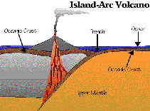 In oceanic-oceanic collisions one
of the edges is forced down into the upper mantle. Oceanic crust is able to sink
into the mantle because its main component, cold basalt, is about the same density
as the mantle rocks. The edge that goes down is called the "descending slab."
Although the descending slab is mostly basalt, it also contains layers of clay, limestone,
and serpentine that formed on the ocean floor. The clay and serpentine contain
water. Limestone is made of minerals combined with carbon dioxide (CO2). As the slab containing all these different kinds of rocks descends into the
mantle, it heats up. The heat causes the rocks containing water and CO2 to decompose, releasing these gases. Dry
basalt will not melt at mantle temperatures, but when it comes in contact with water and
CO2, its melting point is lowered.
The effect is like that which occurs when salt or antifreeze is used to lower the melting
point of water ice to clear roads in winter or to keep the car's radiator from freezing in
cold weather. Consequently, some of the basalt melts and absorbs the water and CO2. The liquid basalt is less dense than the
surrounding solid rocks, so buoyancy forces cause the liquid rock to rise through the
overlying mantle and oceanic crust to form a volcano on the ocean floor. As the lavas pile
up, they form groups of volcanic islands like Japan and Indonesia. In oceanic-oceanic collisions one
of the edges is forced down into the upper mantle. Oceanic crust is able to sink
into the mantle because its main component, cold basalt, is about the same density
as the mantle rocks. The edge that goes down is called the "descending slab."
Although the descending slab is mostly basalt, it also contains layers of clay, limestone,
and serpentine that formed on the ocean floor. The clay and serpentine contain
water. Limestone is made of minerals combined with carbon dioxide (CO2). As the slab containing all these different kinds of rocks descends into the
mantle, it heats up. The heat causes the rocks containing water and CO2 to decompose, releasing these gases. Dry
basalt will not melt at mantle temperatures, but when it comes in contact with water and
CO2, its melting point is lowered.
The effect is like that which occurs when salt or antifreeze is used to lower the melting
point of water ice to clear roads in winter or to keep the car's radiator from freezing in
cold weather. Consequently, some of the basalt melts and absorbs the water and CO2. The liquid basalt is less dense than the
surrounding solid rocks, so buoyancy forces cause the liquid rock to rise through the
overlying mantle and oceanic crust to form a volcano on the ocean floor. As the lavas pile
up, they form groups of volcanic islands like Japan and Indonesia.
The third type of plate collision is continental-continental. The rocks on both sides of this type of collision are too light to sink into the mantle, so the edges simply crumble and fold into giant mountain ranges. The best example of this type of collision is the Himalayan Mountains in central Asia, which are the result of India crashing into Asia. Very little rock in these collisions is forced to great depths, so little melting occurs, and few volcanoes form. (Just in case you are wondering, there are only a few volcanoes in the Himalayas.) So much for plate collisions. What about plate separations? In these cases no rock is forced down to where it can melt, so no volcanoes form, right? Wrong! Nature does it again! Where plates are separating, something must flow in to fill the gap or else we would have giant, open cracks extending hundreds of kilometers into the Earth's interior (talk about your ultimate skydiving experience!). The stuff that flows in is hot, soft rock from the upper mantle. This rock is originally under great pressure, but as it rises into the gap between plates, the pressure drops faster than the rock can cool. A small amount of basaltic rock melts and flows to the surface through cracks. There is little or no dissolved gas in this lava, so the eruptions are not explosive. The amounts of lava erupting at any given time are small, but the eruptions are continuous and occur along all the oceanic ridges, making this type of volcano the most common in the world. Iceland and the Kenya rift are among the very few places on land where this type of volcanism occurs.
[ Locations of Volcanoes: page 1 / page 2 / page 3 / page 4 ] [ Home ] [ Teacher Pages ] [ Modules & Activities ] |
![]()
HTML code by Chris Kreger
Maintained by ETE Team
Last updated October 01, 2010


Discuss Exploring the Environment!
Some images © 2004 www.clipart.com.
Privacy Statement and Copyright © 1997-2004 by Wheeling Jesuit University/NASA-supported Classroom of the Future. All rights reserved.
Center for Educational Technologies, Circuit Board/Apple graphic logo, and COTF Classroom of the Future logo are registered trademarks of Wheeling Jesuit University.
 The most likely intersection of a
flat descending slab with the curved surface of the earth is a long, gentle curve or arc.
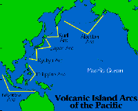
Since the volcanic islands tend to form a few hundred miles "downslab" from the
collision site (marked by a deep trench on the ocean floor), they usually form an
arc-shaped group. The arc shape is easy to see in many examples: the islands of Japan, the
Aleutian Arc extending from the Southwest Coast of Alaska almost to Siberia, and the
Timor-Java-Sumatra chain in Indonesia. Consequently, these types of volcanoes are called
"island arc volcanoes." What kind of eruptions do we get with island arc
volcanoes? Remember, the lava forms because it contains a great deal of dissolved water and
CO2. Thus, when the lava reaches the
surface, the gases are released, making very explosive eruptions. Some of the most
violent historical eruptions are of the island arc type, such as Tambora (1815), Krakatoa
(1883), and Mount Pinatubo (1992).
The most likely intersection of a
flat descending slab with the curved surface of the earth is a long, gentle curve or arc.
Since the volcanic islands tend to form a few hundred miles "downslab" from the
collision site (marked by a deep trench on the ocean floor), they usually form an
arc-shaped group. The arc shape is easy to see in many examples: the islands of Japan, the
Aleutian Arc extending from the Southwest Coast of Alaska almost to Siberia, and the
Timor-Java-Sumatra chain in Indonesia. Consequently, these types of volcanoes are called
"island arc volcanoes." What kind of eruptions do we get with island arc
volcanoes? Remember, the lava forms because it contains a great deal of dissolved water and
CO2. Thus, when the lava reaches the
surface, the gases are released, making very explosive eruptions. Some of the most
violent historical eruptions are of the island arc type, such as Tambora (1815), Krakatoa
(1883), and Mount Pinatubo (1992).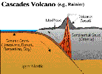 Now let's look at
oceanic-continental collisions. In these cases the oceanic crust always forms a
descending slab beneath the continent because the granite in the continental crust
is too light to sink into the mantle. In the descending oceanic slab the same conditions
for melting occur as before except this time as the liquid rock ascends through the
continental crust, some of the granite is melted and mixed with the liquid lava. Granite
contains lots of silica, so the lava becomes very viscous. Consequently,
when these lavas reach the surface, the resulting eruptions tend to be even more explosive
than the island arc eruptions. The Cascade volcanoes in the American Northwest are the
best studied examples of this type and include Mount Rainier and Mount St.
Helens. A 3-D map showing the Cascades and the prominent volcanoes can be seen by
clicking
Now let's look at
oceanic-continental collisions. In these cases the oceanic crust always forms a
descending slab beneath the continent because the granite in the continental crust
is too light to sink into the mantle. In the descending oceanic slab the same conditions
for melting occur as before except this time as the liquid rock ascends through the
continental crust, some of the granite is melted and mixed with the liquid lava. Granite
contains lots of silica, so the lava becomes very viscous. Consequently,
when these lavas reach the surface, the resulting eruptions tend to be even more explosive
than the island arc eruptions. The Cascade volcanoes in the American Northwest are the
best studied examples of this type and include Mount Rainier and Mount St.
Helens. A 3-D map showing the Cascades and the prominent volcanoes can be seen by
clicking 