 |
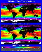
Rogue's Gallery of Natural Disasters: El Niño El Niño is an extreme oscillation in the ocean current patterns of the South Pacific, causing the waters off the coast of South America to become unusually warm. This generally shifts the precipitation patterns in the United States, causing drought and above average temperatures in the Midwest and the central plains areas.
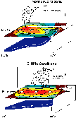
Under normal conditions, atmospheric circulation in the equatorial Pacific is characterized by rising air near Australia and New Guinea and sinking air near Central America and northern South America. This leads to surface winds that blow from east to west along the equator, dragging the warm surface waters westward and allowing colder subsurface waters to rise to the surface off the coast of South America. Under El Niño conditions, the zone of rising air moves to the central Pacific, allowing air to sink over both New Guinea and South America. This causes surface winds to blow eastward from New Guinea, allowing the warm surface waters to move to the east coast of the Americas. As the warm ocean surface waters move into the eastern Pacific, they prevent the cold, deep waters from rising and drive the tropical jet stream northward, altering weather patterns over Mexico and the United States.
[Rogue's Gallery of Natural
Disasters] [Drought Gallery] [Fire
Gallery] [ Home ] [ Teacher Pages ] [ Modules & Activities ] |
![]()
HTML code by Chris Kreger
Maintained by ETE Team
Last updated November 10, 2004
Some images © 2004 www.clipart.com
Privacy Statement and Copyright © 1997-2004 by Wheeling Jesuit University/NASA-supported Classroom of the Future. All rights reserved.
Center for Educational Technologies, Circuit Board/Apple graphic logo, and COTF Classroom of the Future logo are registered trademarks of Wheeling Jesuit University.