Remote Sensing
Remote sensing
is the act of collecting data without directly contacting its source. In its most basic sense, you are engaged in remote sensing as you read this page on your computer. Light emanating from the computer screen travels over a distance until your eyes capture it. Your eyes—sensors,
if you will—send a message to your brain. Your brain records the data and interprets it into information.
Similarly, some remote sensing technologies sample electromagnetic energy. They then extract information about features on the Earth's surface, oceans, and atmosphere. They can even tell you about the exteriors of other planets in the solar system. For example, satellite sensors create images by measuring the amount of infrared and visible light the Earth gives off or reflects. Scientists can analyze these images to estimate things such as the pattern of water or vegetation covering the planet.
Since live coral, dead coral, sand, and algae all reflect light a little differently, scientists can classify pixels in remote sensing images and create maps of large coral reefs. One way scientists evaluate the health of coral reef communities is to look at multiple satellite images that were collected for the same location on Earth at different times. The they try to detect changes in the image classification. In other words they look for changes in the amount of reflected light. Increases in brightness might mean the coral are not as healthy as before. That's because increases in brightness might indicate that the light is reflecting off sand rather than coral, or coral bleaching might be occurring.
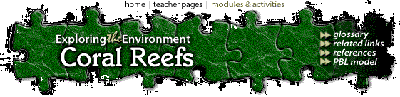
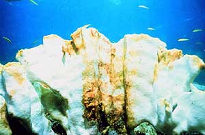 Photo: Coral through the Caribbean are bleaching (casting out their algae). Photo © 2003 www.clipart.com. |
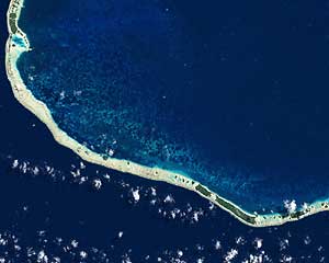 Photo: Coral bleaching in French Polynesia Image courtesy Serge Andrefouet, University of South Florida, based on data from the USGS EROS Data Center. |
For scientists
to really understand a reef, they likely will use a combination of remote
sensing techniques. In addition to satellite imagery, aerial photography
could help in shallow areas.
 Scientists might use LIDAR to map the topography of the sea-floor or use hyperspectral imagery to refine their classification maps. Sea surface temperatures measured by the Advanced Very High Resolution Radiometer (AVHRR) instrument on
weather satellites can show surface temperatures are warmer than normal. Graphic: Nighttime
sea surface temperature measured by the AVHRR instrument carried on NOAA's Polar Orbiting Environmental Satellites.
Scientists might use LIDAR to map the topography of the sea-floor or use hyperspectral imagery to refine their classification maps. Sea surface temperatures measured by the Advanced Very High Resolution Radiometer (AVHRR) instrument on
weather satellites can show surface temperatures are warmer than normal. Graphic: Nighttime
sea surface temperature measured by the AVHRR instrument carried on NOAA's Polar Orbiting Environmental Satellites.
Despite the many tools available, you can't rely on remote sensing to accurately map and evaluate the health of a coral reef. Ground-truthing, is necessary. That's when scientists take direct field measurements of a reef and check them against the remotely sensed data.
Glossary ..|.. Related Links ..|.. References |..PBL Model
Home ..|.. Teacher Pages ..|.. Modules & Activities
Maintained by ETE Team
Last updated
March 08, 2004
Privacy Statement and Copyright © 1997-2004 by Wheeling Jesuit University/NASA-supported Classroom of the Future. All rights reserved.
Exploring the Environment®, Coral Reefs was developed under a cooperative agreement with NASA.
Some images © 2004 www.clipart.com
Center for Educational Technologies, Circuit Board/Apple graphic logo, and COTF Classroom of the Future logo are registered trademarks of Wheeling Jesuit University.