
Remote Sensing
There are several remotely sensed parameters that are used to monitor an ENSO event.
Ocean Surface Winds These are measured by a scatterometer. Microwave radiation from the satellite returns a weak signal from a rough (windy) ocean surface, but it returns a strong signal from a smooth surface (not so windy). A radiometer measures radiation reflected from Earth's surface. Strong winds with white caps on the ocean reflect back more radiation than do calmer conditions.
Cloud Systems and Rainfall Amounts These are monitored by Polar orbiters (NOAA) and geostationary (GOES) satellites. Visual and infrared channels on these satellites allow type, coverage, and thickness of clouds to be determined. Microwave radiation from the satellites will not sense clouds, but will identify larger rain drops, which allow rainfall amounts to be estimated.
Sea Surface Height This is measured by radar altimeters on the TOPEX/POSEIDON satellite and on the European Remote sensing Satellite (ERS-1). Heights greater than normal in areas such as coastal Peru indicate decreased upwelling.
Sea Surface Temperatures These are measured by the Advanced Very High Resolution Radiometer (AVHRR) on NOAA polar orbiters. They determine temperatures by sensing infrared radiation coming from the sea surface. Current temperatures are updated for 4-day periods.
Phytoplankton Productivity This is measured by the Coastal Zone Color Scanner (CZCS) on the Nimbus 7 satellite. Areas of productivity change during ENSO events.
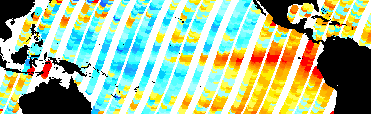
Remote Sensing Activities The monthly averaged sea surface temperature anomalies have been archived for the months for May and June 1997. As you can see, anomalies in May exceeded 2C off the coast of Peru in the eastern Pacific.
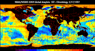 May 1997
 June 1997
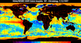 July 1997
Activity 1 The above data are updated often. Download the latest data, and compare the trend in temperature anomalies with those of prior months. Determine whether the anomalous areas are growing larger or smaller and whether their values are increasing or decreasing. Then make a determination of the strength and trend of the current ENSO event.
Activity 2 Sea surface height measurements are used to derive sea level deviations--that is, differences between the average level of the surface of the ocean and the actual levels at particular times. The maps below show sea level deviations in the Pacific Ocean for the period from April 21 to June 29, 1997. Compare these sea level deviation maps with the May and June sea surface temperature maps shown above. Do you see any correlation? What conclusions can you draw?
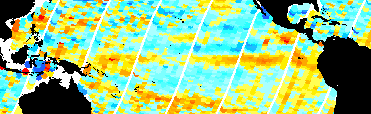
April 1997
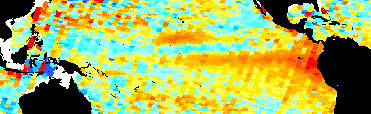
May 1997
June 1997
You can obtain new Pacific Ocean sea level deviation maps at an Internet site maintained at the NOAA Laboratary for Satellite Altimetry. A new map is added every 10 days. You can view the current global map of sea level deviations at the same site. Use these maps to make a graph of the maximum sea level deviations in the Eastern Pacific throughout the course of this ENSO event. Compare your maximum sea level measurements with the maximum sea surface temperatures you obtained in Activity 1, above.
|
[ Glossary ] [ Related Links ] [ References ] [ PBL Model ] [ Home ] [ Teacher Pages ] [ Modules & Activities ] |
![]()
HTML code by Chris Kreger
Maintained by ETE Team
Last updated November 10, 2004
Some images © 2004 www.clipart.com
Privacy Statement and Copyright © 1997-2004 by Wheeling Jesuit University/NASA-supported Classroom of the Future. All rights reserved.
Center for Educational Technologies, Circuit Board/Apple graphic logo, and COTF Classroom of the Future logo are registered trademarks of Wheeling Jesuit University.