
![]()
![]()
![]()
![]()

![]()
Remote
Sensing: Waterflow
Remote sensing is the act of
collecting data without directly contacting its source. For example, scientists
can determine the landscape of the ocean floor without walking on it.
To do this, they send out sound waves from a ship on the ocean's surface.
The sound waves reflect off the ocean floor and back to the ship. The
scientists examine the way the sound waves echo back to the ship to determine
the landscape of the ocean floor below. This method of remote sensing
is called SONAR (SOund NAvigation Ranging).
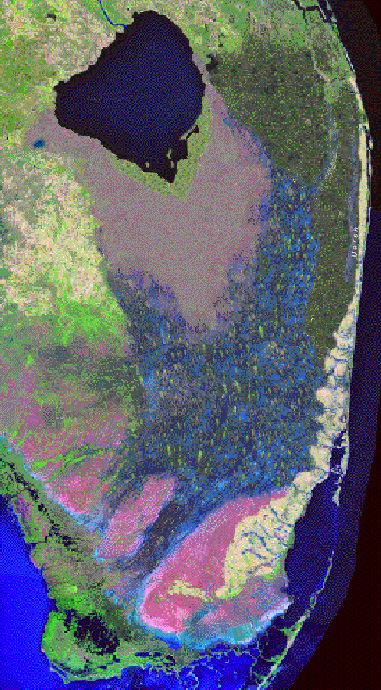 The
flow of fresh water in southern Florida comes mostly from rainfall, 45-60
inches per year, on the Kissimmee River watershed in central Florida.
About 70 percent of the rain falls during the wet season, which lasts
from May to October. Before the conversion of land in southern Florida
to farms and cities, the rain water collected into the Kissimmee River,
flowed down to Lake Okeechobee, and wandered out through the Everglades
to the Gulf of Mexico. The Everglades is a very wide, shallow, and slow
moving body of water. It is about 50 miles wide, ankle to knee deep, and
flows at a speed of about one meter per hour. A broad limestone ridge
that is a few meters high runs down the east coast of southern Florida
and prevents the water from flowing into the Atlantic. During the dry
season (November to April), waterflow slows to practically nothing. For
a few weeks each year, the Everglades sometimes shrinks to a string of
standing pools until the spring rains recharge it. Image:
Synthetic reconstruction of a U.S. Geological Survey satellite image of
how southern Florida probably appeared about 1850.
The
flow of fresh water in southern Florida comes mostly from rainfall, 45-60
inches per year, on the Kissimmee River watershed in central Florida.
About 70 percent of the rain falls during the wet season, which lasts
from May to October. Before the conversion of land in southern Florida
to farms and cities, the rain water collected into the Kissimmee River,
flowed down to Lake Okeechobee, and wandered out through the Everglades
to the Gulf of Mexico. The Everglades is a very wide, shallow, and slow
moving body of water. It is about 50 miles wide, ankle to knee deep, and
flows at a speed of about one meter per hour. A broad limestone ridge
that is a few meters high runs down the east coast of southern Florida
and prevents the water from flowing into the Atlantic. During the dry
season (November to April), waterflow slows to practically nothing. For
a few weeks each year, the Everglades sometimes shrinks to a string of
standing pools until the spring rains recharge it. Image:
Synthetic reconstruction of a U.S. Geological Survey satellite image of
how southern Florida probably appeared about 1850.
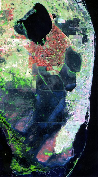 Increased
human habitation in southern Florida significantly changed land and water
use in the area after about 1930. Farmers were attracted to the area by
rich soils. They converted the land south of Lake Okeechobee into farms
and orchards. Tourists and businesses were attracted by the warm weather
and beautiful beaches. They built Miami and other cities along the ridge
on Florida’s east coast. Cities like Orlando grew in the northern
parts of the Kissimmee watershed. More water was needed for agricultural
and urban purposes. This left less water available for the Everglades
ecosystem. In addition, civil engineers constructed an elaborate system
of canals and dikes to channel and drain off water during the wet season.
This was done to prevent flooding of farms and cities. Most of the water
that drained through these canals flowed across the ridge into the Atlantic.
The canals and dikes reduced waterflow through the Everglades even further.
By the 1980s, more than half of the available water in southern Florida
was being diverted for human purposes. As a result, the Everglades ecosystem
was drying up and dying. Image: U.S. Geological
Survey satellite image of southern Florida in 1995.
Increased
human habitation in southern Florida significantly changed land and water
use in the area after about 1930. Farmers were attracted to the area by
rich soils. They converted the land south of Lake Okeechobee into farms
and orchards. Tourists and businesses were attracted by the warm weather
and beautiful beaches. They built Miami and other cities along the ridge
on Florida’s east coast. Cities like Orlando grew in the northern
parts of the Kissimmee watershed. More water was needed for agricultural
and urban purposes. This left less water available for the Everglades
ecosystem. In addition, civil engineers constructed an elaborate system
of canals and dikes to channel and drain off water during the wet season.
This was done to prevent flooding of farms and cities. Most of the water
that drained through these canals flowed across the ridge into the Atlantic.
The canals and dikes reduced waterflow through the Everglades even further.
By the 1980s, more than half of the available water in southern Florida
was being diverted for human purposes. As a result, the Everglades ecosystem
was drying up and dying. Image: U.S. Geological
Survey satellite image of southern Florida in 1995.
Restoration projects initiated in the 1990s are designed to redirect large amounts of water back into the Everglades. Some land south of Lake Okeechobee and land bordering populated areas around Miami will become wetlands again. Surface flow and mean annual hydroperiod maps illustrate the flow and surface coverage of water in southern Florida at three periods in time: 1) about 1950--before major agricultural and urban development, 2) the late 1990s, and 3) about 2050--after completion of the restoration projects.
Overview
| Land Use | Waterflow
| Habitat
Glossary
..|..
Related
Links
..|..
References
|..PBL
Model
Home ..|.. Teacher Pages ..|.. Modules & Activities
HTML code by Chris
Kreger
Maintained by ETE Team
Last updated
April 28, 2005
Some images © 2004 www.clipart.com
Privacy Statement and Copyright © 1997-2004 by Wheeling Jesuit University/NASA-supported Classroom of the Future. All rights reserved.
Center for Educational Technologies, Circuit Board/Apple graphic logo, and COTF Classroom of the Future logo are registered trademarks of Wheeling Jesuit University.