
  |
How Are Hurricanes Formed?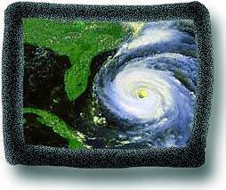 Left: Image produced by Hasler, Pierce, Palaniappan & Manyin of NASA's
Goddard Laboratory for Atmospheres - Data from NOAA Left: Image produced by Hasler, Pierce, Palaniappan & Manyin of NASA's
Goddard Laboratory for Atmospheres - Data from NOAAHurricanes begin as tropical storms over the warm moist waters of the Atlantic and Pacific Oceans near the equator. (Near the Phillippines and the China Sea, hurricanes are called typhoons.) As the moisture evaporates it rises until enormous amounts of heated moist air are twisted high in the atmosphere. The winds begin to circle counterclockwise north of the equator or clockwise south of the equator. The reatively peaceful center of the hurricane is called the eye. Around this center winds move at speeds between 74 and 200 miles per hour. As long as the hurricane remains over waters of 79F or warmer, it continues to pull moisture from the surface and grow in size and force. When a hurricane crosses land or cooler waters, it loses its source of power, and its wind gradually slow until they are no longer of hurricane force--less than 74 miles per hour. Hurricanes over the Atlantic often begin near Africa, drift west on the Trade Winds, and veer north as they meet the prevalling winds coming eastward across North America. Hurricanes over the Eastern Pacific begin in the warm waters off the Central American and Mexican coasts. Eastern and Central Pacific storms are called "hurricanes." Storms to the west of the International Date Line are called "typhoons." Because of the destructive force of hurricanes during late summer and early autumn, scientists constantly monitor them with satellites and sometimes even fly airplane surveillance to keep track of tropical storms that might develop into hurricanes.
[ It's Raining Cats & Dogs ] [ What Are Hurricanes? ] [ Home ] [ Teacher Pages ] [ Modules & Activities ] |
![]()
HTML code by Chris Kreger
Maintained by ETE Team
Last updated April 28, 2005
Some images © 2004 www.clipart.com
Privacy Statement and Copyright © 1997-2004 by Wheeling Jesuit University/NASA-supported Classroom of the Future. All rights reserved.
Center for Educational Technologies, Circuit Board/Apple graphic logo, and COTF Classroom of the Future logo are registered trademarks of Wheeling Jesuit University.