
   |
Homes near Mount Rainier in perilous mudflow path
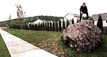
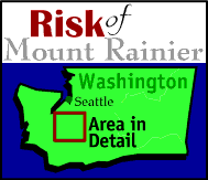
Geology. Though the last massive mudflows occurred centuries ago, geologists continue to sound warnings about the potential destruction such catastrophic events could bring to populated areas. The alerts also are an example of how the U.S. Geological Survey's mission has changed in recent years. Orting, Pierce County--For the 100,000 residents who live in river valleys around Mount Rainier, the U.S. Geological Survey (USGS) has a disquieting message for the 15th anniversary of the eruption of Mount St. Helens on May 18. "Homes in this area are in greater risk of being hit by a mudflow from Mount Rainier than a risk of catching on fire," said Kevin Scott, a USGS research hydrologist who has been mapping the hazard for a decade. Scott made his assessment near the stumps of trees killed by the Electron debris flow of 500 years ago, a flood that buried the Orting Valley with mud and rock up to 50 feet thick. The mudflow was not triggered by a volcanic eruption that would have given some warning but probably by a sudden earthquake, Scott explained. "These flows, because they start as a landslide, can occur at any time," he said. Starting its rush down Rainier in excess of 100 mph, the land and water slide--with a consistency of wet concrete--is estimated to have been moving at about 41 mph as it surged down river valleys, reaching the Orting area in one to two hours with a tangle of rock, clay, water, trees and ice chunks. Scott Fielding, the fire chief in this community, said that if such a mudflow occurred today, residents might get only 40 minutes notice even if warning instruments were in place. There is no instrumentation on Mount Rainier today, such as modern acoustic flow monitors, to give such warning. Yet across the street from stumps buried 500 years ago, on top of the old flow, a subdivision of new homes is rising within Orting's city limits. The back yard of one new home backs onto an automobilesize boulder carried more than 30 miles from Mount Rainier by the violent flood. The threat brought a shrug from a developer. "We are aware that 500 years ago there was a mudflow and that we're building on top of that mudflow," said Brian Housley, one of the partners who owns the Whitehawk subdivision property of $110,000 to $150,000 homes. Other partners did not return phone calls. "Pierce County passed an ordinance in November to limit home density on land in the valley to one home per five acres because of potential danger from the volcano," said county planner Mark Truckey. The county also blocked Orting from building a new school on county land in the valley. Truckey is sympathetic to the political dilemma of this town of 2,400 people. "We'd like to see similar restrictions for adjacent cities," he noted. "However, Orting's city limits are all within the mudflow area. They have a much more difficult decision than we do." Warnings go unheard Fielding, the fire chief, said he has been frustrated in trying to educate valley residents on Rainier's danger. Town meetings have been called in Orting the past three years, but "turnout has been marginal to nil," he said. While the Orting Valley is rapidly growing in population, "to evacuate more people on our existing road system is very difficult," Fielding warned. The decision of USGS to highlight the potential risk from a type of disaster that on average occurs just once in 500 to 1,000 years illustrates why the agency has been the object of debate in Congress this year. The federal geologists in the 115-year-old agency have been moving in recent years from an emphasis on mineral mapping to identification of geologic risks, such as earthquake and volcanic hazards in the Pacific Northwest. It also produces topographic maps popular with hikers and monitors rivers to give flood warnings. None of this seems very compelling to some East Coast legislators, and USGS warnings can appear downright hostile to would be land developers in geologically sensitive areas. Conservative Republicans, led by House Budget Committee Chairman John Kasich of Ohio, have tentatively proposed eliminating the bad-news agency. In response USGS has cut its work force 10 percent, spun off some of its work to private contractors and has started courting public recognition of what it does. New studies compare mudflow risk, which few insure against, to fire risk, which almost everyone insures against, to show the warnings have relevance. Greater than fire risk USGS cites a Federal Emergency Management Agency study showing that smaller mudflows that occur on an average of every 100 years are 27 times more likely than fire to hit homes near the mountain. Geologists have extrapolated that to the rarer 500 to 1,000 year events that can flow as far as Puget Sound at Tacoma's Commencement Bay. A similar flow surged down the Toutle River Valley from Mount St. Helens in 1980, causing extensive damage and temporarily plugging the shipping channel in the Columbia River. Cascade Range volcanoes as a group have averaged a major eruption about once a century. Rainier is considered the most dangerous because so many people live near it. "Most true conservatives are in favor of people knowing the risks and then having the freedom of basing decisions on knowing those risks," said Scott, the geologist. But when Pierce County decided to block Orting's plan to site a new school on county land on the Electron debris flow, it turned to Scott and the USGS for expertise to back its position. "We've defined risk in a way that will stand up in court," said Scott, who has been studying Mount Rainier's potential dangers for 10 years. Mount Rainier last erupted about 150 years ago and hasn't had an eruption greatly modifying its shape for at least 1,200 years. When the Electron flow roared down the Orting Valley, Columbus had just discovered America. And while the Osceola mudflow exceeded in volume the collapse of Mount St. Helens and reached the present sites of Auburn and Tacoma, it occurred 5,000 years ago.
The pile of volcanic debris nearly three miles high is so heavy that "the crust underneath is quivering like a bowl of Jell-O," Scott said. Small earthquakes around the peak are routine. Its interior is permeated by hot water and steam that erode the cohesion of the rock, making sudden landslides possible. And the volcano has about a cubic mile of permanent ice and snow--or as much as all other Cascade volcanoes combined--that could melt and give way. The Osceola mudflow decapitated the top 2,000 feet of the volcano, creating an east-facing amphitheater similar to that seen today on Mount St. Helens. Subsequent eruptions created the new twin-coned peak seen today. Similar but smaller mudflows have roared off the mountain every 500 to 1,000 years as wedges of Rainier collapse. Smaller flows are common, particularly "outburst floods" from water accumulating in melting glaciers. In 1947 the terminus of the Kautz glacier collapsed and carried a mudflow for nine miles burying a half mile of national-park road and creating a "ghost forest" of dead trees. Outburst floods of trapped water erupted from Nisqually glacier in 1926, 1932, 1934, 1955, 1968, 1970, 1972, and 1985. Similar smaller floods of water and debris have roared down Tahoma Creek from South Tahoma Glacier almost annually. Just since 1986, a gorge beneath a bridge on the Wonderland Trail has deepened from 30 feet to 80 feet from the erosive power of repeated debris flows. And, in 1989, enough rock to fill the Kingdome slid down a flank of the mountain and triggered seismic instruments up to 120 miles away. Scott and Driedger said the lesson is that the eruption of Mount St. Helens was no fluke. "We're not in the business of proposing regulations. Our job is to do basic science. Mount Rainier is the single greatest volcanic risk in the Cascade Range. What people choose to do about it is their business," Scott said. Reprinted with permission of The Seattle Times
[ Orting in Pictures ] [ Mountain of Risk ] [ Mud / Waterflows around Mount Rainier ] [ Home ] [ Teacher Pages ] [ Modules & Activities ] |
![]()
HTML code by Chris Kreger
Maintained by ETE Team
Last updated September 30, 2010


Discuss Exploring the Environment!
Some images © 2004 www.clipart.com.
Privacy Statement and Copyright © 1997-2004 by Wheeling Jesuit University/NASA-supported Classroom of the Future. All rights reserved.
Center for Educational Technologies, Circuit Board/Apple graphic logo, and COTF Classroom of the Future logo are registered trademarks of Wheeling Jesuit University.


 By Bill Dietrich,
 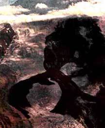 Not as
benign as it looks But the volcano is not as benign as it looks,
explained Scott and hydrologist Carolyn Driedger.
Not as
benign as it looks But the volcano is not as benign as it looks,
explained Scott and hydrologist Carolyn Driedger.