


 |
Environmental History
Wheeling was first settled in 1769 near the site of Fort Henry. National Road, U.S. Route
40, was completed to Wheeling in 1818, making it the first road link from the East Coast
to the Ohio River. This opened Wheeling as a gateway to western expansion for European
settlement of the United States.
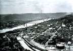 Downtown
Wheeling in 1890 shows a highly industrialized urban center,
including river and rail transportation facilities, as well as bridges carrying roads
across the Ohio River. River travel was essential to the expansion of Wheeling's
industrial base. Photo:
Courtesy of the Oglebay Institute, Wheeling, WV Downtown
Wheeling in 1890 shows a highly industrialized urban center,
including river and rail transportation facilities, as well as bridges carrying roads
across the Ohio River. River travel was essential to the expansion of Wheeling's
industrial base. Photo:
Courtesy of the Oglebay Institute, Wheeling, WV |
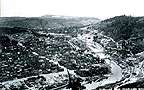 Wheeling from
Chapline Hill in 1890 shows lower Wheeling Creek from about 2
km (1.2 mi.) upstream. Notice that lower Wheeling Creek had been dredged to provide barge
access to new industrial sites. Photo: Courtesy of the Oglebay Institute, Wheeling, WV Wheeling from
Chapline Hill in 1890 shows lower Wheeling Creek from about 2
km (1.2 mi.) upstream. Notice that lower Wheeling Creek had been dredged to provide barge
access to new industrial sites. Photo: Courtesy of the Oglebay Institute, Wheeling, WV |
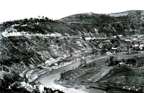 McCullock's
Leap Area in 1892 shows the area about 3 km (1.9 mi.) upstream
from the Ohio River. What features can you identify from these photographs that may have
impacted the biological communities of Wheeling Creek? Photo:
Courtesy of the Oglebay Institute, Wheeling, WV McCullock's
Leap Area in 1892 shows the area about 3 km (1.9 mi.) upstream
from the Ohio River. What features can you identify from these photographs that may have
impacted the biological communities of Wheeling Creek? Photo:
Courtesy of the Oglebay Institute, Wheeling, WV |
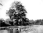
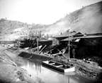 Site of
Wheeling Creek Wall in 1890 provides a closer examination of
the stream. Note the structure of the stream banks, stream bed, plants growing in the
stream bed, streamside vegetation, and the vegetation on the hillsides along lower
Wheeling Creek. Photo: Courtesy
of the Oglebay Institute, Wheeling, WV Site of
Wheeling Creek Wall in 1890 provides a closer examination of
the stream. Note the structure of the stream banks, stream bed, plants growing in the
stream bed, streamside vegetation, and the vegetation on the hillsides along lower
Wheeling Creek. Photo: Courtesy
of the Oglebay Institute, Wheeling, WV |
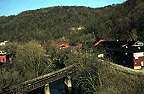 Site of Wheeling
Creek Wall in 1996 From the same view as above, can you tell
what this stream looked like in 1890? Photo: Courtesy of Dr. Ben Stout Site of Wheeling
Creek Wall in 1996 From the same view as above, can you tell
what this stream looked like in 1890? Photo: Courtesy of Dr. Ben Stout |
 Scene on Big
Wheeling Creek in 1904 Compare these features to those of the
photo approximately 12 km (7.5 mi.) upstream. What are the similarities and differences
between these areas of the Wheeling Creek watershed? Did U.S Route 40 and the Baltimore
and Ohio Railroad travel along this site on Big Wheeling Creek? Photo: Courtesy of the Oglebay Institute,
Wheeling, WV Scene on Big
Wheeling Creek in 1904 Compare these features to those of the
photo approximately 12 km (7.5 mi.) upstream. What are the similarities and differences
between these areas of the Wheeling Creek watershed? Did U.S Route 40 and the Baltimore
and Ohio Railroad travel along this site on Big Wheeling Creek? Photo: Courtesy of the Oglebay Institute,
Wheeling, WV |
[ Background Information ]
[ Site Description & Photos ]
[ Remote Sensing ] [ Environmental History ]
[ Glossary]
[ Related Links ] [ References
] [ PBL Model ]
[ Home
] [ Teacher Pages ] [ Modules
& Activities ]
|