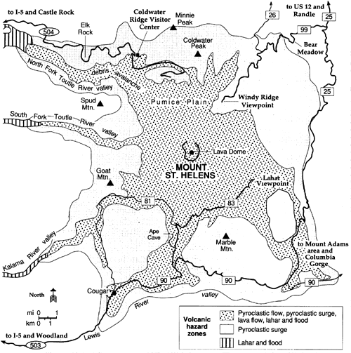
| Figure 4 This preliminary volcanic hazards map, redrawn from one prepared by the U.S. Geological Survey (U.S. Forest Service, 1992), shows hazard zones close to Mount St. Helens volcano that could be at great risk in the event of a major eruption. The patterned areas would be evacuated and closed to the public. Such eruptive activity is typically preceded by a systematic increase in seismic activity that would give adequate warning. The hazard zone for lateral blasts and heavy tephra fallout would encompass the area within a 50-km radius of the volcano (beyond that shown). (Compare with Fig.1.) |
|
HTML code by Chris
Kreger Some images © 2004 www.clipart.com Privacy Statement and Copyright © 1997-2004 by Wheeling Jesuit University/NASA-supported Classroom of the Future. All rights reserved. Center for Educational Technologies, Circuit Board/Apple graphic logo, and COTF Classroom of the Future logo are registered trademarks of Wheeling Jesuit University.
|