Skip Navigation

  Button that takes you back to the home page. Button that takes you to the Problem Based Learning model. Button that takes you to the teacher pages. Button that takes you to the modules and activities page. Button that takes you to the References page. Button that takes you to the Related Links page. Button that takes you to the Glossary page.Image map of some Earth on Fire puzzle pieces.  Please have someone assist you with this.

Button that takes you to the Rogue's Gallery of Natural Disasters page.
Button that takes you to the Drought Gallery page.
Button that takes you to the Fire Gallery page.
Image that says Flood Gallery.
Button that takes you to the Hurricane Gallery page.
Button that takes you to the Ice Gallery page.
Button that takes you to the El Nino Gallery page.
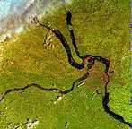
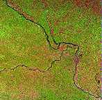
Rogue's Gallery of Natural Disasters: Flood
The droughts were followed by periods of above-average precipitation, which resulted in flooding such as the Mississippi River floods of 1993. There was also flooding in the Pacific Northwest in the fall of 1995 and 1996. The Ohio River flooded in January 1996, and the Red River, in the spring of 1997. While flooding is not new, many of these floods were severe. The Mississippi flood was a 100- or 200-year flood, and the Red River flood is thought to have been a 500-year flood.
  Image showing the extent of the flooding in Missouri during the record rains of 1993.  This image links to a more detailed image. Image showing the Missouri river before the record rains of 1993.  This image links to a more detailed image. 

These landsat images illustrate the extent of the flooding in Missouri during the record rains of 1993. The left image (L02403300932310) was taken in late August 1993, at the height of the flood. The flooded Missouri, Mississippi, and Illinois Rivers stand out vividly in this image. Water covers much of the flood plain along each of the rivers. St. Louis is located just below the confluence of the Mississippi and Missouri Rivers. The right image (L0240330096272) was taken in late September 1996, and shows the rivers in a typical year. The flood plains are also apparent in the 1996 image even without the flood waters because they are characterized by slightly different types of vegetation and land use. Each image is about 185 km across. North is to the upper left. Acknowledgment: These data are distributed by the EROS Data Center Distributed Active Archive Center (EDC DAAC), located at the U.S. Geological Survey's EROS Data Center in Sioux Falls, SD.

[Rogue's Gallery of Natural Disasters] [Drought Gallery] [Fire Gallery]
[Flood Gallery] [Hurricane Gallery] [Ice Gallery] [El Niño Gallery]
[ Glossary] [ Related Links ] [ References ] [ PBL Model ]

[ Home ] [ Teacher Pages ] [ Modules & Activities ]

Button that takes you back to Earth on Fire's main page.


HTML code by Chris Kreger
Maintained by ETE Team
Last updated November 10, 2004

Some images © 2004 www.clipart.com

Privacy Statement and Copyright © 1997-2004 by Wheeling Jesuit University/NASA-supported Classroom of the Future. All rights reserved.

Center for Educational Technologies, Circuit Board/Apple graphic logo, and COTF Classroom of the Future logo are registered trademarks of Wheeling Jesuit University.