Skip Navigation

  Button that takes you back to the home page. Button that takes you to the Problem Based Learning model. Button that takes you to the teacher pages. Button that takes you to the modules and activities page. Button that takes you to the References page. Button that takes you to the Related Links page. Button that takes you to the Glossary page.Image map of some Earth on Fire puzzle pieces.  Please have someone assist you with this.

Button that takes you to the Rogue's Gallery of Natural Disasters page.
Button that takes you to the Drought Gallery page.
Button that takes you to the Fire Gallery page.
Button that takes you to the Flood Gallery page.
Button that takes you to the Hurricane Gallery page.
Image that says Ice Gallery.
Button that takes you to the El Nino Gallery page.
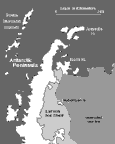
Rogue's Gallery of Natural Disasters: Ice
On a more global scale, in 1995 a large section of the Antarctic Ice Shelf disintegrated. If the ice shelf and glaciers continue to melt, sea level worldwide will increase by several meters. This will inundate many coastal cities and could cover nearly the entire state of Florida.
Image showing the seasonal sea ice around the Antarctic Peninsula.  This image links to a more detailed image.  Image of a near-infrared AVHRR image documenting the collapse of part of the Larsen Ice Shelf bordering the Antarctic Peninsula. This image links to a more detailed image. 

This near-infrared AVHRR image documents the collapse of part of the Larsen Ice Shelf bordering the Antarctic Peninsula. The original extent of the ice shelf is outlined on the map above left. The entire northern end of the shelf disintegrated into the grayish swath of ice fragments stretching across the center of the image between Ross and Robertson Islands. Another large section broke free as a giant iceberg, visible at the lower center. The map inset at the top shows Rhode Island and part of Massachusetts for comparison. This image was taken on February 27, 1995, about two weeks after the giant iceberg broke free from the main ice shelf. This is exactly the type of event that had been predicted by scientists modeling the effects of global warming.

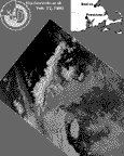
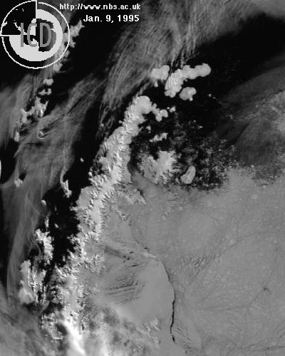
The progress of the collapse can be seen in a short five-frame movie. The first frame was taken on January 9, 1995, after the northern part of the shelf had fragmented but before the "superberg" had broken off. The second image was taken on February 12, 1995, and the third, the image below, was taken on February 27. The last image was taken nearly two years later, in January of 1997. The superberg is gone as is nearly all of the ice shelf north of Robertson Island. The four satellite images were captured by the ARIES receiving station at the Rothera research station located on Adelaide Island off the west coast of the Antarctic Peninsula. Original images provided by Tom Lachlan-Cope and Russ Ladkin. Co-registration of the images and the map is by S.K. Croft.

To download individual frames of the animation go to the data_sets page.

[Rogue's Gallery of Natural Disasters] [Drought Gallery] [Fire Gallery]
[Flood Gallery] [Hurricane Gallery]
[Ice Gallery] [El Niño Gallery]
[ Glossary] [ Related Links ] [ References ] [ PBL Model ]

[ Home ] [ Teacher Pages ] [ Modules & Activities ]

Button that takes you back to Earth on Fire's main page.


HTML code by Chris Kreger
Maintained by ETE Team
Last updated November 10, 2004

Some images © 2004 www.clipart.com

Privacy Statement and Copyright © 1997-2004 by Wheeling Jesuit University/NASA-supported Classroom of the Future. All rights reserved.

Center for Educational Technologies, Circuit Board/Apple graphic logo, and COTF Classroom of the Future logo are registered trademarks of Wheeling Jesuit University.