|
|
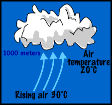
Atmosphere Before examining the atmosphere during El Niño conditions, take a look at the normal non-El Niño situation, beginning in the tropical Pacific. Compared to cool air, warm air is less dense and is capable of holding more moisture in the form of water vapor. As a result of its low density, warm air low in the atmosphere tends to rise, expand, and cool. Every 1000 feet, it cools 5.5 Fahrenheit (10°C every 1000 m). Since this cooled air is no longer able to hold as much moisture, its moisture begins to condense into water droplets and form clouds. The opposite effect occurs in the atmosphere when air descends--it warms and dries.
Normal Global Circulation Earth's atmosphere is constantly in motion, an event we experience as constantly changing winds, weather, and cloud patterns. Wind patterns are very complex, especially at scales less than 100 kilometers. If these wind directions and speeds are averaged over large sections of Earth's surface, a global circulation pattern emerges--a pattern shaped by solar heating and Earth's rotation. Solar Heating Large-scale circulations develop in Earth's atmosphere due to uneven heating of its surface by the Sun's rays. Daytime solar heating is greatest near Earth's equator, where incoming sunlight is nearly vertical to the ground, and smallest near both poles, where sunlight arrives nearly horizontal to the ground. Near the poles, heat lost to space by radiation exceeds the heat gained from sunlight, so air near the poles is losing heat. Conversely, heat gained from sunlight near the equator exceeds heat losses, so air near the equator is gaining heat. The heated air near the equator expands and rises, while the cooled air near the poles contracts and sinks. The combination of these two processes sets up a general circulation pattern: air rises near the equator, flows north and south away from the equator at high altitudes, sinks near the poles, and flows back along the surface from both poles to the equator. This type of flow is called Hadley circulation after George Hadley, an English meteorologist of the eighteenth century, who first described the process.
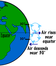
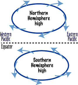
Rotation Simple Hadley circulation is modified by Earth's rotation. A parcel (small volume) of air near the equator moves eastward in the direction of Earth's rotation with a speed of nearly 1700 kilometers per hour. Parcels at higher latitudes move at slower speeds; parcels at the poles do not have any rotational speed at all. Consequently, a parcel of air carried away from the equator by Hadley circulation finds itself moving eastward faster than the air or ground below it. An observer on the ground looking at the parcel would see it veer on a curved path to the east as if moved by some force. Similarly, a parcel of air moving away from either of the poles would be moving more slowly than the ground, thus appearing to veer to the west. The apparent force causing this veering is called the Coriolis force. As winds flow out of subtropical high-pressure areas centered near 30° latitude, they are turned to the right in the Northern Hemisphere and to the left in the Southern Hemisphere. The result is a clockwise flow around the Northern Hemisphere high and a counterclockwise flow around the Southern Hemisphere subtropical high. Friction causes the airflow to depart slightly and come out from the highs, as seen in Figure 3. Near the equator the winds are nearly easterly. These are called the Easterly Tradewinds. The Inter Tropical Convergence Zone (ITCZ) occurs where the tradewinds of the two hemispheres meet. This is an area of enhanced rainfall because the warm, moist air is forced upward, where it cools and the water vapor condenses.
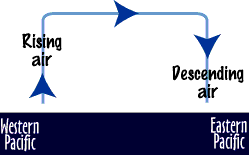
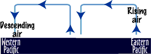
Walker Cells If you follow the airflow around the subtropical high-pressure area in the South Pacific Ocean, you can see that the airflow around the eastern part of the ocean is from the higher, colder latitudes. Surface ocean water follows a similar path. As both the air and water begin to move westward near the equator, they gradually warm. When they reach the Western Pacific, the warm air tends to rise. As it rises and cools, it moves eastward, where it descends over the eastern Pacific, warming and drying until it reaches an altitude of about 1000 m. It stops there because the air below is much colder and denser. The rising air over the western Pacific creates a very wet climate, while over much of the eastern Pacific the climate is dry. This type of air circulation is called a Walker cell, commemorating Sir Gilbert Walker, who first hypothesized its existence.
The Hadley cell causes air to rise near the equator, and the Walker cell results in air rising over the western Pacific Ocean. So, in general, rainfall amounts increase near the equator, and as you travel westward across the Pacific. Changes During El Niño During an El Niño year, the very large circulations of air across the Pacific Ocean break down. Warmer than normal water appears in the eastern Pacific, and colder than normal water appears in the western Pacific. The Easterly Tradewinds weaken and sometimes even reverse. The normal Walker cell breaks down and may look something like the depiction in Figure 5.
This change in the atmospheric circulation and water temperatures generally results in increased rainfall in the eastern Pacific (coastal Chile and Peru, for example), and decreased rainfall in the western Pacific (Australia and Indonesia, for example). The effects of El Niño, however, do not end there. Teleconnections cause the unusual conditions of El Niño to affect weather worldwide. Worldwide El Niño Events It now appears that worldwide atmospheric events are associated with El Niño. In the Atlantic Ocean, the frequency of tropical cyclones tends to decrease. High tropospheric westerly winds replace the normal extensive easterlies in the Atlantic. The resulting shear (easterlies near the surface, westerlies aloft) makes it difficult for these storms to develop vertically. In 1983, an El Niño year, there were only four Atlantic tropical cyclones of tropical storm intensity or greater. In 1995, a non-El Niño year, there were 19 such storms. Although El Niño was probably not responsible for the entire difference between these two years, it very likely had some influence.
Over southeast Canada, a strong low-pressure area and cold temperatures developed. Downstream from this low, strong westerly winds aloft brought wet, mild winters to Western Europe. Rainfall in the western Pacific, especially in India and Australia, tended to be well below normal. Typical conditions that occur with an El Niño (warm ENSO episode) are shown here.
[ Atmosphere ] [ Biosphere ] [ Hydrosphere ] [ Lithosphere ] [ Home ] [ Teacher Pages ] [ Modules & Activities ] |
|||||
![]()
HTML code by Chris Kreger
Maintained by ETE Team
Last updated November 10, 2004
Some images © 2004 www.clipart.com
Privacy Statement and Copyright © 1997-2004 by Wheeling Jesuit University/NASA-supported Classroom of the Future. All rights reserved.
Center for Educational Technologies, Circuit Board/Apple graphic logo, and COTF Classroom of the Future logo are registered trademarks of Wheeling Jesuit University.