
 |
 A
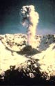
Fitful Doze Volcanic activity at Mount St. Helens declined
significantly after the May 18 blast. Smaller explosive eruptions continued throughout the
remainder of 1980, with a final one in early 1982. Most of the ash from these eruptions
blew eastward, but on two occasions winds carried some ash westward into the heavily
populated Columbia River valley. A volcanic dome was formed on the floor of the central
crater by a series of small lava eruptions, the last of these occurring in 1986. Minor
steam explosions continued into the early 1990s. A
Fitful Doze Volcanic activity at Mount St. Helens declined
significantly after the May 18 blast. Smaller explosive eruptions continued throughout the
remainder of 1980, with a final one in early 1982. Most of the ash from these eruptions
blew eastward, but on two occasions winds carried some ash westward into the heavily
populated Columbia River valley. A volcanic dome was formed on the floor of the central
crater by a series of small lava eruptions, the last of these occurring in 1986. Minor
steam explosions continued into the early 1990s.
 The only activity at present is marked by the rumble
of small earthquakes, but the situation may change at any time. Mount St. Helens sleeps,
but the sleep is fitful. Given its violent past, Mount St. Helens will awake again in the
not too distant future. Photo: University of Colorado. Courtesy of NGDC/NOAA Photo: Dept. of Natural Resources, State of Washington.
Courtesy of NGDC/NOAA. The only activity at present is marked by the rumble
of small earthquakes, but the situation may change at any time. Mount St. Helens sleeps,
but the sleep is fitful. Given its violent past, Mount St. Helens will awake again in the
not too distant future. Photo: University of Colorado. Courtesy of NGDC/NOAA Photo: Dept. of Natural Resources, State of Washington.
Courtesy of NGDC/NOAA.
From the events in this narrative of the 1980 Mount St. Helens eruption, consider what might happen if Mount Hood or Mount Rainier or Mount Shasta should awaken from its dormant state with a May 18-size eruption, or more incredibly, with a Mazama-scale eruption. For an extended discussion of Mount St. Helens, see http://vulcan.wr.usgs.gov/ljt_slideset.html
[ Narrative of Mt. St. Helens: page 1 / page 2 / page 3 ] [ Home ] [ Teacher Pages ] [ Modules & Activities ] |
![]()
HTML code by Chris Kreger
Maintained by ETE Team
Last updated November 10, 2004
Some images © 2004 www.clipart.com
Privacy Statement and Copyright © 1997-2004 by Wheeling Jesuit University/NASA-supported Classroom of the Future. All rights reserved.
Center for Educational Technologies, Circuit Board/Apple graphic logo, and COTF Classroom of the Future logo are registered trademarks of Wheeling Jesuit University.
 The
Toll To the nation--and especially to those living
nearby--the May 18 eruption seemed of apocalyptic proportions. The crown and heart of a
whole mountain had been blasted away, and the surrounding countryside devastated. The
energy released by the eruption was estimated at ten megatons, an explosion thousands of
times stronger than the Hiroshima bomb. Thousands of deer, elk, bear, and smaller animals
perished--in addition to 57 humans. Two hundred thirty-two square miles of forest were
destroyed, including three billion board feet of timber estimated at $400 million in value
(U.S. Senate Hearings, 1980). Numerous buildings, bridges, roads, and machines were
destroy
The
Toll To the nation--and especially to those living
nearby--the May 18 eruption seemed of apocalyptic proportions. The crown and heart of a
whole mountain had been blasted away, and the surrounding countryside devastated. The
energy released by the eruption was estimated at ten megatons, an explosion thousands of
times stronger than the Hiroshima bomb. Thousands of deer, elk, bear, and smaller animals
perished--in addition to 57 humans. Two hundred thirty-two square miles of forest were
destroyed, including three billion board feet of timber estimated at $400 million in value
(U.S. Senate Hearings, 1980). Numerous buildings, bridges, roads, and machines were
destroy
 ed, and farms and communities up to a thousand miles
away were partially buried in ash. One hundred sixty-nine lakes and more than 3,000 miles
of streams had either been marginally damaged or destroyed (U.S. Senate Hearings, 1980).
Losses to property and crops were set at more than $1.8 billion. Yet, the impact on human
life could have been much greater if the main eruption had occurred on a workday or if the
blast had been directed southwest toward the Portland/Vancouver metropolitan area, just 45
miles away, or if the wind had been blowing toward the southwest. Photo: Dept. of
Natural Resources, State of Washington. Courtesy of NGDC/NOAA. Map: Courtesy of
NGDC/NOAA.
ed, and farms and communities up to a thousand miles
away were partially buried in ash. One hundred sixty-nine lakes and more than 3,000 miles
of streams had either been marginally damaged or destroyed (U.S. Senate Hearings, 1980).
Losses to property and crops were set at more than $1.8 billion. Yet, the impact on human
life could have been much greater if the main eruption had occurred on a workday or if the
blast had been directed southwest toward the Portland/Vancouver metropolitan area, just 45
miles away, or if the wind had been blowing toward the southwest. Photo: Dept. of
Natural Resources, State of Washington. Courtesy of NGDC/NOAA. Map: Courtesy of
NGDC/NOAA. As large and destructive as the May 18 eruption
appeared, seen in context, it was a relatively small eruption. Thick deposits of older
volcanic rock around Mount St. Helens attest to much larger eruptions in its past.
Mount St. Helens is also only one of many volcanoes that dot the Cascade Range from
northern California to southern Canada (see map). All of these volcanoes grew in the same
geologic setting and are of the same explosive type as Mount St. Helens. Some eruptions at
other Cascade volcanoes have been truly huge, such as the explosion nearly 7000 years
ago--one hundred times larger than the May 18 eruption--that reduced Mount Mazama to
Crater lake and spread ash all across the United States. Eruptions ranging in size from
the May 18 eruption to the Mazama blast could occur at any time at any of the Cascade
volcanoes. The metropolitan centers of Portland, Seattle-Tacoma, and Berkeley-San
Francisco have grown up among the Cascade volcanoes. Map:
Courtesy of NGDC/NOAA.
As large and destructive as the May 18 eruption
appeared, seen in context, it was a relatively small eruption. Thick deposits of older
volcanic rock around Mount St. Helens attest to much larger eruptions in its past.
Mount St. Helens is also only one of many volcanoes that dot the Cascade Range from
northern California to southern Canada (see map). All of these volcanoes grew in the same
geologic setting and are of the same explosive type as Mount St. Helens. Some eruptions at
other Cascade volcanoes have been truly huge, such as the explosion nearly 7000 years
ago--one hundred times larger than the May 18 eruption--that reduced Mount Mazama to
Crater lake and spread ash all across the United States. Eruptions ranging in size from
the May 18 eruption to the Mazama blast could occur at any time at any of the Cascade
volcanoes. The metropolitan centers of Portland, Seattle-Tacoma, and Berkeley-San
Francisco have grown up among the Cascade volcanoes. Map:
Courtesy of NGDC/NOAA.