
 Lithosphere
The lithosphere is the outermost part of the solid earth. It includes Earth's surface. The lithosphere is made up of plates. These plates move against each other, causing some regions of Earth's surface to rise and others to fall. The rise and fall of Earth's surface under the oceans can have major effects on coral reefs. Volcanoes can affect coral reefs in a different way. Although volcanoes have their sources deep in Earth's interior, they penetrate through the lithosphere. Photo:
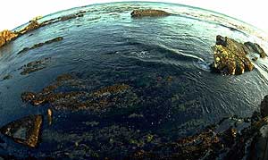
Coral reef and islands barely above sea level. Photo © 2003 www.clipart.com.
Rise and Fall of the Lithosphere
Did you know there are islands on Earth that are capped with coral at elevations of more than 300 meters (about 1,000 feet)? Christmas Island in the Indian Ocean is an example. How did the coral reach such a height? The answer has to do with the movement of Earth's plates and the rising of the lithosphere in some places. For the most part, though, coral atolls and islands are usually very close to sea level and flat.
Coral grow very slowly—between .5 and 2.8 centimeters per year (2.4 centimeters equals one inch). This growth rate normally is enough to keep the coral close to the ocean's surface even if the lithosphere is sinking or the level of the sea is rising. (Sea level rises when glaciers melt.)
 |
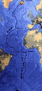 |
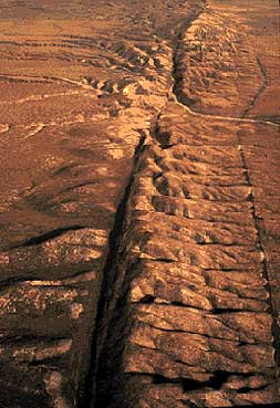
| Photo: An aerial view shows probably the most familiar meeting of two plates in the United States, the San Andreas fault slicing through the Carrizo Plain in the Temblor Range east of the city of San Luis Obispo, CA. Photograph by Robert E. Wallace, USGS. | Map: The Mid-Atlantic Ridge, which splits nearly the entire Atlantic Ocean north to south, is probably the best-known and most-studied example of a divergent-plate boundary. Illustration adapted from the map, This Dynamic Planet. |
Vol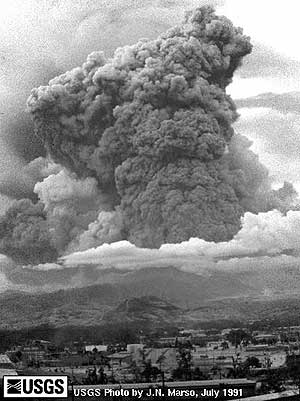 canoes
In the winter of 1992 following followed the eruption of Mount Pinatubo, a volcano in the Philippines, coral were seen dying in the Gulf of Aqaba. This area is located in the northern part of the Red Sea between the Arabian peninsula and Africa. It was the coldest winter in the 46 years since weather reports had been made for that area. Mount Pinatubo had injected large amounts of sulfuric acid aerosol high into the stratosphere. This aerosol reflected sunlight, resulting in the cooler than average weather. Photo: The eruption of Mount Pinatubo in the Philippines was the second biggest volcanic eruption of the 20th century and was 10 times bigger than the eruption of Mount St. Helens in Washington in 1980. The volcanic residue from the explosion caused coral to die in the Red Sea. Photo courtesy of Jeff Marso, July 1991, USGS.
When the Red Sea coral began to die, scientists looked for possible reasons—volcanic dust's smothering the coral, presence of hydrogen sulfide (H2S), disease, or some combination of causes. When scientists measured water temperatures, though, they found cold water mixed very thoroughly to great depths. (Cold water is usually found very deep with warmer water near the surface.) Here's what had happened: The unusually cold surface water had sunk, helping to mix the water column. This helped to also mix nutrients (like phosphorous) that normally stay deep in the cold water to near the water's surface. This resulted in the growth of thick, red algal blooms. They are thought to have smothered the coral, blocking out the sunlight. When temperatures returned to normal, the algal blooms died because they no longer had the nutrients they needed. The reefs were soon healthy again.
 This incident shows how an event in the lithosphere (volcanic eruption) can influence the atmosphere and hydrosphere (colder temperatures) and eventually affect the biosphere (coral dying).
Dust
When drought occurs in West Africa, some Caribbean coral dies. West African dust, which is thickest during drought years, is transported by winds to the Caribbean. This dust carries the fungus aspergillus, which thrives on sea fans, a type of coral. Thick dust can also block out the sun's rays, resulting in reduced photosynthesis. Photo: Dust storm on the African savanna. Photo © 2003 www.clipart.com.
Anthrosphere | Atmosphere | Biosphere | Hydrosphere | Lithosphere
Glossary ..|.. Related Links ..|.. References |..PBL Model
Home ..|.. Teacher Pages ..|.. Modules & Activities
Maintained by ETE Team
Last updated
March 08, 2004
Privacy Statement and Copyright © 1997-2004 by Wheeling Jesuit University/NASA-supported Classroom of the Future. All rights reserved.
Exploring the Environment®, Coral Reefs was developed under a cooperative agreement with NASA.
Some images © 2004 www.clipart.com
Center for Educational Technologies, Circuit Board/Apple graphic logo, and COTF Classroom of the Future logo are registered trademarks of Wheeling Jesuit University.