
    |
Amazon Rainforest: View from Space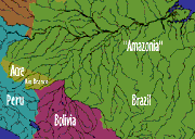 Some types of changes in the
Amazonian rain forest are easy to see, even from space. To help you with your analysis,
the GRIN panel has made available to your group a set of images showing the region
surrounding the city of Rio Branco in the western Amazon basin. Rio Branco is the capital
of the Brazilian state of Acre (see map). Some types of changes in the
Amazonian rain forest are easy to see, even from space. To help you with your analysis,
the GRIN panel has made available to your group a set of images showing the region
surrounding the city of Rio Branco in the western Amazon basin. Rio Branco is the capital
of the Brazilian state of Acre (see map).As with many locales in the rainforest, the area around Rio Branco has seen many changes in the last few years: an exploding population (see table below), competition for resources, and even outbursts of violence like the old American West. Rio Branco boasts many different types of people: wealthy ranchers, dirt-poor farmers, an assortment of city merchants and workers, miners, loggers, corporate businessmen, environmentalists, migratory rubber tappers (centered around the town of Xapuri), and tribes of native Indians. Some of these people view the rainforest as an enemy to be destroyed, some see it as free goods to be disposed of in any way possible that makes lots of money, and some see it as home.
*Population numbers are estimated Analysis of satellite imagery allows the overall impact of people on the rain forest to be clearly seen; it allows measurement and evaluation to help decide what is happening, how fast it is happening, and where it is happening. Activity 1: seeing environmental change and activity 2: measuring environmental change of the Remote Sensing Activities present two groups of suggested image processing activities, Image Processing Procedures provides detailed directions for most of the processing procedures, and the Landsat Image Set contains the list of satellite images. This set of images and the suggested image processing activities will give your group some of the information it needs to analyze the situation and to make informed and responsible recommendations. Note: Working on the image processing activities requires leaving your World Wide Web browser (Netscape, Mosaic, etc.) and opening a separate image processing program to work on the images. Therefore, for practical reasons, we recommend that you do the following while you are still in your Web browser:
[ Amazon Rain Forest: View from Space ] [ Seeing
Environmental Change ] [ Home ] [ Teacher Pages ] [ Modules & Activities ] |
|||||||||||||||||||||||||
![]()
Page created by Chris Kreger
Maintained by ETE Team
Last updated November 10, 2004
Some images © 2004 www.clipart.com
Privacy Statement and Copyright © 1997-2004 by Wheeling Jesuit University/NASA-supported Classroom of the Future. All rights reserved.
Center for Educational Technologies, Circuit Board/Apple graphic logo, and COTF Classroom of the Future logo are registered trademarks of Wheeling Jesuit University.