Korea from Space
 Cameras on Shuttles and satellites
provide us with views of the earth that we can imagine only with difficulty from our
ground-based perspective. Images taken from space help us to see geographic and
topographic relationships of cities, farmlands, mountains, rivers, and valleys in local,
regional and global settings. Information about land use, vegetation cover, mineral
deposits, and near-surface geology can be obtained more easily from space-based images
than from surveys taken on the ground. Here are some selected images of the Korean
peninsula illustrating local and regional features.
Cameras on Shuttles and satellites
provide us with views of the earth that we can imagine only with difficulty from our
ground-based perspective. Images taken from space help us to see geographic and
topographic relationships of cities, farmlands, mountains, rivers, and valleys in local,
regional and global settings. Information about land use, vegetation cover, mineral
deposits, and near-surface geology can be obtained more easily from space-based images
than from surveys taken on the ground. Here are some selected images of the Korean
peninsula illustrating local and regional features.
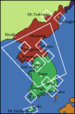
Shuttle Photographs In
addition to conducting experiments on Space Shuttle flights, astronauts usually take many
photographs of the surface of the earth. There now exists an archive containing literally
thousands of Shuttle photographs that may be viewed by anyone with access to the Internet
(http://earthrise.sdsc.edu/earthrise/maps/).
The map to the right shows the outlines of representative Shuttle images of Korea. Simply
click inside one of the white frames, and a photograph of the area will appear.
 Not all shuttle photographs are
clear or particularly useful to the casual user. Even clear photographs like the ones here
are not always easy to interpret ("Uh. Where did you say that city was?"). If
you wish, you can work through a short tutorial on how to identify common features like
cities, mountains, and farmlands in shuttle images.
Not all shuttle photographs are
clear or particularly useful to the casual user. Even clear photographs like the ones here
are not always easy to interpret ("Uh. Where did you say that city was?"). If
you wish, you can work through a short tutorial on how to identify common features like
cities, mountains, and farmlands in shuttle images.
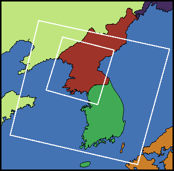
Satellite Images The map at the left shows the white outlines of a few selected satellite images. To see an image, just click within an outline. These images look a little strange because they are "false color." For example, plants show up as shades of pink and red. However, the images show large sections of the Korean peninsula much better than the shuttle images.
Please Note: these images are between 35-80k and may take some time to download.
[ Seoul
] [ Seoul
Area
] [ Pohang
] [ Taegu
] [ Punchbowl
] [ P'yongyang
] [ Home ] [ Teacher Pages ] [ Modules & Activities ] |
![]()
HTML code by Chris Kreger
Maintained by ETE Team
Last updated April 28, 2005
Some images © 2004 www.clipart.com
Privacy Statement and Copyright © 1997-2004 by Wheeling Jesuit University/NASA-supported Classroom of the Future. All rights reserved.
Center for Educational Technologies, Circuit Board/Apple graphic logo, and COTF Classroom of the Future logo are registered trademarks of Wheeling Jesuit University.