
 |
Precipitation & Water Supply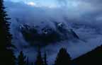 Water
Supply Factors such as snow melt and rainfall are obvious
contributors to the water supply of a given area. In the coastal regions of the Northwest,
a less obvious yet highly significant source of water is fog drip. Right: Clouds and sea mist around the Olympic
Mountains, WA. Photo: Ed Shay Water
Supply Factors such as snow melt and rainfall are obvious
contributors to the water supply of a given area. In the coastal regions of the Northwest,
a less obvious yet highly significant source of water is fog drip. Right: Clouds and sea mist around the Olympic
Mountains, WA. Photo: Ed ShayAs chilled moist ocean air is pulled inland, its moisture transforms into a layer of low-lying fog. The fog passes through the trees, and the sharp slender needles of the conifers provide numerous points for condensation. The resulting droplets drip from the needles to the ground beneath adding valuable moisture to the watershed. An example of the significant role fog drip plays in contributing to water supply comes from data generated by the Portland Bureau of Water Works. The average annual rainfall for Portland is approximatly 40 inches while average total runoff for the Bull Run watershed, Portland's primary water source, is 135 inches. The research project conducted within the Bull Run Municipal watershed area and quoted below demonstrates that a substantial portion of this increased water supply comes from fog drip associated with an old-growth forest.
Although it is not what might be expected, one of the consequences of cutting trees in an area is a decrease in water supply and stream flow. Precipitation Activity 2. Look at a topographical map of the same area. 3. Examine the precipitation data charts for the four locations:
4. Do you see a pattern in the precipitation data? What might be the relationship between the topographic information and the precipitation data? How might the topography of this area impact the seasonal differences in precipitation? Hint: Dry weather comes with the summer months and is associated with high-pressure weather systems flowing across the peninsula from the northwest. Rain returns to the Olympic forests in October, when weather systems begin to flow from the southwest. [ Diversity ] [ Ecosystem Flexibility ] [ Natural & Human
Disturbance ] [ Home ] [ Teacher Pages ] [ Modules & Activities ] |
![]()
HTML code by Chris Kreger
Maintained by ETE Team
Last updated November 10, 2004
Some images © 2004 www.clipart.com
Privacy Statement and Copyright © 1997-2004 by Wheeling Jesuit University/NASA-supported Classroom of the Future. All rights reserved.
Center for Educational Technologies, Circuit Board/Apple graphic logo, and COTF Classroom of the Future logo are registered trademarks of Wheeling Jesuit University.