![]()
![]()
![]()
Week Ten:
Larsen Ice Shelf Disintegration
Global
Ice & Sea Level
In 1995 sections of
the Larsen Ice Shelf collapsed and disintegrated.
 |
 |
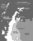
The original extent of the Larsen Ice Shelf, which borders the Antarctic Peninsula, is outlined on the map (above left).
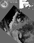
Two parts of this ice shelf have collapsed. The progress of the collapse can be seen in a short five-frame movie featuring near-infrared AVHRR images. To download individual frames of the animation go to the data_sets page.
- The first frame was taken on January 9, 1995, after the northern part of the shelf had broken off and fragmented.
- The second frame was taken on February 12, 1995. This frame shows the fragmented ice, which is the grayish swath moving to the right, away from the Larsen Ice Shelf. This frame also shows that another section of the Larsen Ice Shelf has broken free as a giant iceberg, a “superberg.”
- The third, the right image shown above, was taken on February 27, about two weeks after the superberg had broken free from the Larsen Ice Shelf. The superberg, which is visible at the lower center of the image, was similar in size to the state of Rhode Island. The map inset above the image shows Rhode Island for size comparison. The entire northern end of the shelf, which had disintegrated into the grayish swath of ice fragments about a month before the superberg broke off, can be seen stretching across the center of the image between Ross and Robertson Islands.
- The fourth frame was taken nearly two years later, in January of 1997. The superberg is gone as is nearly all of the ice shelf north of Robertson Island.
- The final frame is the map seen above on the left to show where the entire Larsen Ice Shelf had been located.
The four satellite images were captured by the ARIES receiving station at the Rothera research station located on Adelaide Island off the west coast of the Antarctic Peninsula. Original images provided by Tom Lachlan-Cope and Russ Ladkin. Co-registration of the images and the map is by S.K. Croft.
Over Weeks 10 and 11, you will be analyzing the Larsen Ice Shelf disintegration event as you complete your Sphere Study Assignment and Event Study Assignment.
![]()
Week
by Week ...Week
One ...Week
Two ...Week
Three ...
Week Four ...Week
Five ...Week
Six ...Week
Seven ...Week
Eight ...
Week
Nine ...Week
Ten ...Week
Eleven ...Week
Twelve ...
Week
Thirteen ...Week
Fourteen ...Week
Fifteen ...Week
Sixteen ...
Home ...Intro ...Guide ...Classroom
...
![]()


Maintained by ESSC Team
Last Updated July 26, 2000
Privacy Statement and Copyright© 1997-2000 by Wheeling Jesuit University/NASA Classroom of the Future™. All rights reserved.