![]()
![]()
![]()
Week Four:
Deforestation
Brazilian Deforestation
Since 1975 Rondonia, Brazil
has experienced a rapid growth in population due to immigration from surrounding
states. Farmers have colonized the region adjacent to the main highway
to take advantage of the cheap land offered by the government. The highway
appears as the north-south traversing linear feature about one-third of
the way from the eastern (right) edge of the image.
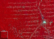
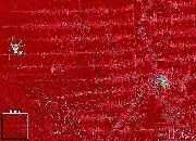
The three images shown below were taken by remote sensing satellites in low earth orbit. Vegetation is shown as red to highlight differences in plant type and health. Areas where forested lands were converted to agricultural uses are identifiable in the 1986 and 1992 images as a "fishbone" pattern extending east and west from the highway.
 |
 |
 |
|
The contrast between the 1975 and 1986 images indicates the extensive change that had occurred in only 11 years. In 1975, almost no areas of deforestation can be seen. By 1986 the fishbone pattern of deforested land had extended over 20 km (12.5 mi) from the highway into the forest. By comparing satellite images such as these, NASA researchers have shown that over 24,000 square kilometers of forest were converted to agriculture in Rondonia between 1975 and 1986. The 1986 image was taken in August when the soil of the agricultural fields is exposed. It appears as light blue squares in the fishbone pattern.
In the seven years between the 1986 and 1992 images, the clearing of forested lands continued at a rapid pace, extending the cleared fishbone pattern deeper into the forest, as is seen in the 1992 image. According to the best satellite-based estimates, over 6% of the Brazilian Amazon Rainforest has been deforested. Due to forest fragmentation, however, over 16% of the forest has been affected by deforestation. The 1992 image was taken in June when the fields have crops growing in them. This makes the fishbone pattern appear lighter red than the surrounding forest.
Over Weeks 4 and 5, you will be analyzing the deforestation event as you complete your Sphere Study Assignment and Event Study Assignment.
![]()
Week
by Week ...Week
One ...Week
Two ...Week
Three ...
Week Four ...Week
Five ...Week
Six ...Week
Seven ...Week
Eight ...
Week
Nine ...Week
Ten ...Week
Eleven ...Week
Twelve ...
Week
Thirteen ...Week
Fourteen ...Week
Fifteen ...Week
Sixteen ...
Home ...Intro ...Guide ...Classroom
...
![]()


Maintained by ESSC Team
Last Updated July 26, 2000
Privacy Statement and Copyright© 1997-2000 by Wheeling Jesuit University/NASA Classroom of the Future™. All rights reserved.