 |
|
NDVI image |
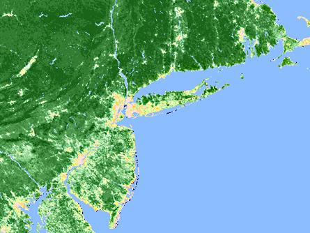 This image shows the level of greenness or richness of vegetation in the New York region. Deep shades of green indicate vegetation. Light greens, browns and yellows indicate residential and urban areas with little or no vegetation. Specifically, the image shows the Normalized Difference Vegetation Index (NDVI), which is derived from data obtained using an Advanced High Resolution Radiometer (AVHRR) on board an NOAA TIROS satellite. The data were taken during September of 1992. Source: These data are distributed by the EROS Data Center Distributed Active Archive Center (EDC DAAC), located at the U.S. Geological SurveyÕs EROS Data Center in Sioux Falls, SD. [ next ] ... |