

![]()
![]()
![]()
![]()
![]()
![]()
![]()
![]()
![]()

|
What
is the focus of this module? What is the compelling problem that students will face in this module? Your students will study the action of Hurricane Andrew (1992) in preparation for analyzing, tracking, and predicting landfall of the next hurricane to hit the United States this school year. What tasks will students encounter as they work through this module? Few students are aware of the variables involved in weather-related events or the magnitude of destruction hurricanes involve. This ETE module contains background information on hurricanes and prescribes three major tasks: 1. Tracking a Hurricane for Practice 2. Working in groups, students should apply the Problem-Based Learning model to the problem.
3. Building upon students' experiences tracking Hurricane Andrew and the Remote Sensing Resources in the module, have them
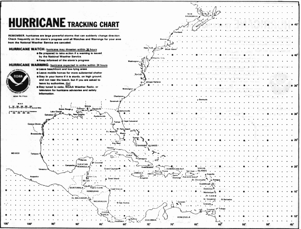
print out this Hurricane Tracking Sheet and then use hurricane tracking shareware downloaded from the internet. (Macintosh users may elect to use the McHurricane software, while Windows 3.1 and Windows 95 users may elect to track using Tracking The Eye.) Using image processing software predict at least 24 hours in advance where and when this hurricane will come ashore. Note: This activity needs to be scheduled over several days due to the actual length of time a hurricane runs its course. How can one determine precisely when a satellite photo was taken? Satellites take many pictures. How do you know you are looking at the most recent one? How long ago was the picture taken? Most satellite images have the time written on them, but it is in a form that may be difficult to read. Here is a guide to finding the time. As you know, there are many different time zones around the globe. The one generally used on satellite images is universal time (U.T.), also known as zulu time (Z), and Greenwich mean time (GMT). All three refer to the time in London along the Greenwich Meridian. When a satellite picture is taken, it is logged according to traditional military notation for time (that is, the 24-hundred hour notation). So if you see a picture taken at 0830 U.T., this means it was taken at 8:30 a.m. universal time. You can use a chart to convert a U.T., Z, or GMT time to the zone where you live.To convert to standard time in North America, subtract the appropriate number of hours from the chart below. To convert to zones outside North America, use the U.S. Naval Observatory's World Time Zones page.
To get daylight saving time, add one hour to your answer. Thus, if the satellite image was made Friday at 1500 hours (fifteen hundred hours) Greenwich mean time, then the time on the East Coast of the United States was 1000 hours (10 hundred hours). If daylight saving time was in effect, add one hour. Preparation Checklist--have you thought of everything? |
![]()
![]()
![]()
![]()
![]()
![]()
![]()
![]()
![]()
![]()
![]()
![]()
![]()
![]()
![]()
![]()
![]()
![]()
|
Grade
Level: 5-12
|
|
Resources for this module Teacher
to Teacher Hurricane! An Event-Based Science Module. by Russell G. Wright Addison-Wesley ISBN 0-201-49094-3; Student Editions are $5.95 and a Teacher's Guide comes with a videotape of news coverage for $15.00. Classroom packages are $71.96. Addison-Wesley's toll free number is (800) 552-2259. Millennium Weather Tropical Page The site contains a unique hurricane forecasting technique TRANTECH (TRopical ANalog TECHnique). The site also contains a host of hurricane related information and links. Project Earth Science: Meteorology, by P. Sean Smith & Brent A. Ford. National Science Teachers Association (NSTA) Publications ISBN 0-87355-123-0 (1994) The Weather Book: An Easy-to-Understand Guide to the USA's Weather, by Jack Williams. Vintage Books (a division of Random House) ISBN 0-679-73669-7 (1992) The Weather Companion: An Album of Meteorological History, Science, Legend and Folklore, by Gary Lockhart. Wiley Science Editions, John Wiley and Sons, Inc. ISBN 0-471-62079-3 (19880 Nature on the Rampage, by H.J. DeBlij. Smithsonian Books, Smithsonian Institution. ISBN 0-89599-048-2 (1994) Hurricane! An Event-Based Science Module, by Russell G. Wright. Addison-Wesley Publishing Company. ISBN 0-201-49094-3 (1995) The Weather Classroom, by Karen Wenning Moore. Developed by the Weather Channel Education Services. ISBN 1-882227-00-x (1992) USA Today, Weather Page Local TV and Radio Weather Shows |
HTML code by Chris
Kreger
Maintained by ETE
Team
Some images © 2004 www.clipart.com
Privacy Statement and Copyright © 1997-2004 by Wheeling Jesuit University/NASA-supported Classroom of the Future. All rights reserved.
Center for Educational Technologies, Circuit Board/Apple graphic logo, and COTF Classroom of the Future logo are registered trademarks of Wheeling Jesuit University.